How one of the 18th Century’s leading civil engineers
put a river in the wrong place
By Feargal Sharkey
The Postman’s Son
For the son of a London postal runner William Shackell led a colourful if not turbulent life. As a Freeman of the City of London and proprietor of the notorious John Bull newspaper he was imprisoned three times for libel, declared a bankrupt, became the manufacturer of the printing ink used to print the Penny Black stamp and in 1841 founded the oldest fly fishing club in the country still fishing the same stretch of river, the Amwell Magna Fishery.1 Quite an achievement for any man, but behind William’s sparkle lay some of the more common frailties of human life: power, politics and greed.
Today the Amwell Magna Fishery still owns a two mile section of the River Lea running between Ware and the village of Stanstead Abbotts. But sadly, due to man’s intervention and over-engineering, it is now one of the few remaining stretches of the original River Lea flowing south from Hertford and is perhaps the last place on the river where it is still possible to watch brown trout spawning during the autumn months. Situated below Amwell Hill it is the river fished by Izaak Walton in the 17th century and where he contemplated the art of fishing and ‘studied to be quiet’, but four hundred years earlier it had been at the centre of a struggle between Church and Crown.
Shortly after his ascension to the throne King Edward I began an investigation into how the nobility claimed their local powers and privileges. The crown was seeking to recover any right for which a royal grant could not be found or proved. Throughout the country landowners were summoned to appear before Edward’s Justices, to prove by Quo Warranto (“by what warrant”) they held their titles and estates. One of the first to be examined was the Abbey of Waltham Holy Cross, a medieval powerhouse whose abbots appeared before Justice John de Reygate at Hertford in 1278.
The abbots argued that the Abbey of Waltham had been granted land in Hertford, Wermelay, Brikendon and Stanstead by Richard I on September 18th 1199 and that this grant had been confirmed by Edward’s father, Henry III. Henry, they claimed, had in 1251 given them the right of “free warren” over their lands as full as “royal power could make them”. This it transpired included an exclusive and private right of fishing on the River Lea from Ware to Stanstead Abbotts.2 John de Reygate allowed the abbots’ claim and for the next 253 years the Manor of Stanstead and the exclusive right of fishing in the River Lea would remain part the abbey’s vast estates.
Fishing of course had yet to become a sporting pastime and fisheries were both socially and economically vital. Fish played a significant part in the medieval diet, particularly on Fridays, during Lent, Advent and other religious holidays. The abbots had in fact been granted a commercial monopoly by the Crown. Henry VIII however was to change everything and in 1540 the estates of the Abbey of Waltham were to transfer to the Crown, the Abbey being the last of the great monasteries to be closed during the Dissolution.
In 1559 Elizabeth I awarded the Manor of Stanstead to her General Surveyor of the Victuals for the Seas, Edward Bashe. The estate was to remain in the family for several generations until it was augmented with the purchase of the Manor of Rye in 1691. The Manor of Rye also included fishing rights in the River Lea, running between Stanstead Abbotts and Hoddesdon and these were added to the existing fishery.
1676 saw yet more change and the Manor of Stanstead was sold to Edmund Feilde, barrister and politician following his election as MP for Hertford the previous year. His political career however was to be short lived; Edmund was to die in 1676 without making his maiden speech in parliament. His family would retain the Manor of Stanstead for a further 160 years and are still remembered today in the naming of Feilde’s Weir and Feilde’s Lock that sits at the confluence of the rivers Lee and Stort.
Amwell Magna Fishery
William Henry Feilde, the last of the family to own the estate, died on the 13th January 1833. Three years later on March 14th 1836 his decendents sold at a public auction in Hertford several pieces of property in and around the village, Stanstead Corn Mill, the Red Lion Inn, land, houses, the Smith’s shop and “an extensive and valuable right of fishery in the River Lea.”3
The fishery was described as running between the Tumbling Bay weir at Ware downstream to the confluence with the River Lee Navigation, just north of the village of Stanstead Abbotts, exactly as it stands today.
The New River Company, as the winning bidder promptly added the Stanstead Abbotts Fishery to their existing fishery at Ware and in a matter of weeks had leased four miles of the River Lea, from the Manifold Ditch to Stanstead Abbotts, to three sporting gentlemen, Sir Francis Chantry (Sculptor), William Whitbread (grandson and heir to Samuel of the brewing dynasty) and Henry Warburton MP.4
It was at this point that fishing on the River Lea began the transition from a commercial to a sporting activity.
Chantry’s occupation of the fishery would appear to have been a somewhat unhappy affair. The New River Company were having trouble exercising their exclusive right of fishing in the river as many local people believed that the fishing was free.
In a letter dated May 12th 1840, Chantry wrote to the board of the New River Company describing how he walked along the river from Stanstead to Ware and along the way encountered “No less than seven poachers all hard at work fishing in various ways” and that “five of the poachers were bargemen” that “ten or a dozen were no uncommon sight” and that “on one occasion seventeen people of all sorts were seen fishing at the same time”. He continued: “the river had been netted more than usual this season, and that too under the sanction and even superintendence of some of the River Lea Trustees who encouraged the bargeman to believe the New River Company have no exclusive right of fishing.”
For decades there had been mounting tension between the New River Company and the River Lee Trustees (who controlled the River Lee Navigation), over various rights in the river. The Trustees complained that the New River Company were abstracting too much water from the river reducing the depth in the canal, disputes over who controlled the water rights, fishing rights and rights of way all of which resulted in the River Lee Water Act 1855.5
By 1841 Chantry had resigned his lease and on July 1st the board of the New River Company received a letter stating that “Being exceedingly partial to the sport of angling, I have to request the favour of your accepting me as your tenant… I will endeavour with a few friends to conciliate the neighbouring gentry and at the same time to support your Rights on the River in a way that I trust will be satisfactory to all parties.” On July 15th the New River Company granted a new lease, to William Shackell Esq, founder of the Amwell Magna Fishery.
When the club was formed great efforts were made, not only to exert the exclusive right of fishing on the river but also to protect the fishery; in short, for the past 172 years the fishery and the river were largely removed from the public’s gaze.
Millers, Landowners & Barges
But Kings and abbots were not the only ones to struggle for control of the river. Over a century and a half after the club was formed we began to explore the historical ownership of the river. It was then that we stumbled upon Richard Thomas’s website which details the history of the Lee and Stort navigations and Dr Keith Fairclough’s seminal work on the history of the River Lea.
Of particular interest were several references in Dr Fairclough’s work to the two weirs we have on the fishery, or rather how the owner of Stanstead Mill, Thomas Feilde, (father of William Henry who’s estate was to sell the mill to the New River Company), and the miller Michael Pepper, contrived to block the main river forcing bargemen to travel down the head of the millstream and charging them a 1/- (one shilling) toll in the process.
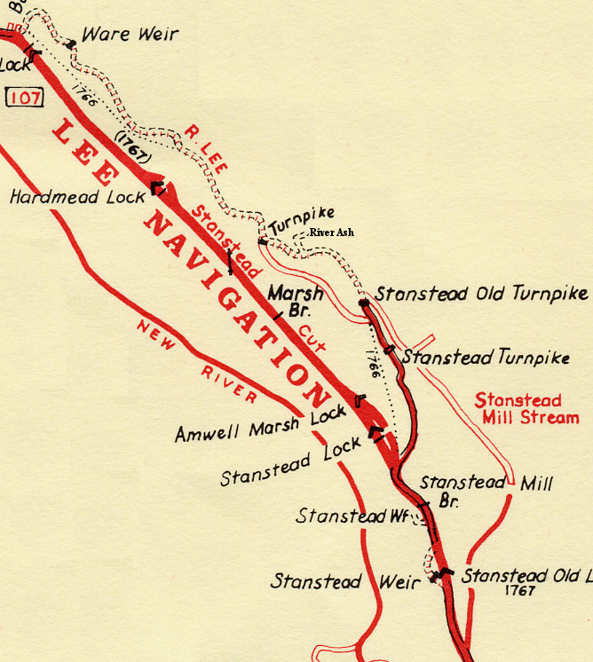
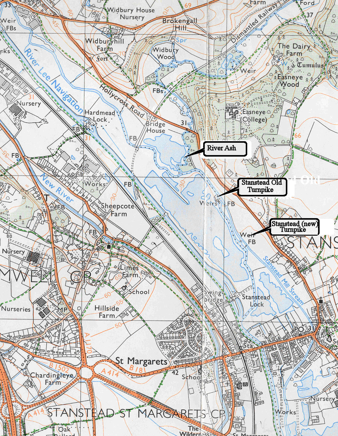
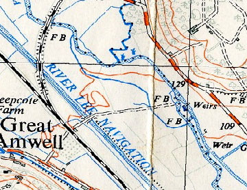
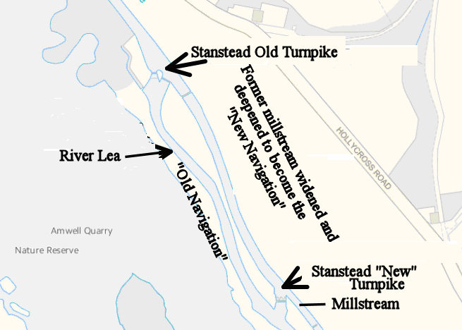
Richard Dean’s map below shows the positions of the two weirs, marked Stanstead Old Turnpike and Stanstead Turnpike. And below this as they are shown on a modern OS map. For convenience, from this point onwards I will use the names applied by Richard Dean with the addition of the ‘New’ for the more recently constructed of the two weirs.
Stanstead Old Turnpike
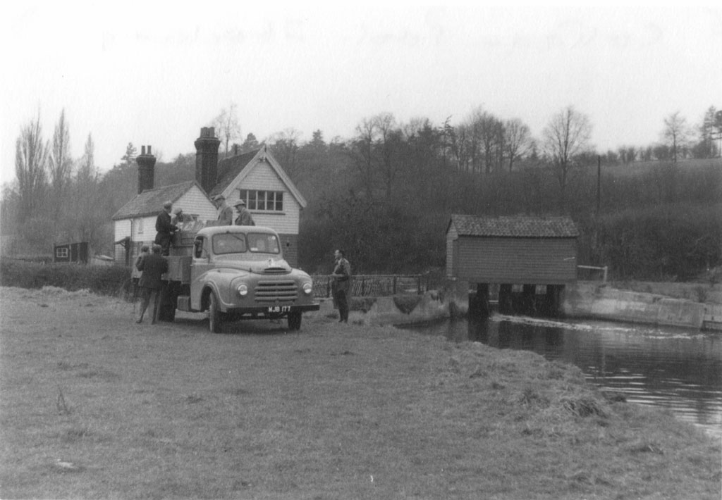
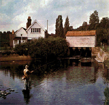
This weir sits across the main river at the mouth of the millstream and controls the amount of water diverted into the stream. Below is how it looked in the 1950s.
As you can see the main river is in the foreground with the weir and its covered walkway in the background. And below right is how it looked like by the early 1970s just before it was replaced with a new fixed crest weir.
In the 1950s picture the main river approaches the weir from the left, behind the houses and falls over the weir towards the viewer. This basic layout and style of the weir has remained unchanged since the early 1800s. The mouth of the millstream is on the right, behind the weir.
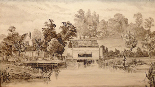
As a historical footnote, the buildings in the picture comprise of two houses. The smaller one on the left is the original river keepers’ cottage built by the New River Company in 1839 and first occupied by a river keeper employed by Sir Francis Chantry, Thomas Litchfield. When the Amwell Magna Fishery was formed in 1841 Thomas continued to work for the club until he became the lock keeper at Ware Lock in 1850. It had been a longstanding arrangement between the club and the New River Company that they jointly employed the river keepers who doubled as lock / weir keepers, here at Stanstead Old Turnpike and at the Tumbling Bay weir at Ware.
Stanstead Old Turnpike was still manually controlled until 1971 when the last river keeper, Keeper Fox retired. He was the last occupant of Keepers’ Cottage. As was normal for the times the larger of the two buildings is the clubhouse built by the club in 1888.
Stanstead New Turnpike
Since the building of the River Lee Navigation in the late 1700s little has changed on the river except for one thing: the position of the Stanstead New Turnpike. It was originally a few meters further north from its current location.
That was until the mid 1970s when as part of the Lee Valley Flood Alleviation Scheme all of the weirs within the fishery, which were still manned by a lock keeper, were removed and replaced by fixed crest weirs. The new weir was built just to the south along the bank of the millstream, the southernmost weir shown in the modern OS Map.
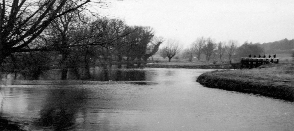
Here however is how the original Stanstead New Turnpike weir looked back in the 1950s before it was removed.
This picture was taken looking upstream on the main river; the weir is on the right with the river on the left flowing towards the viewer. The millstream is also on the right, behind the weir and the grass bank. As can be seen from the top of the weir it contained six sluice gates to control the flow of water from the millstream back into the main river. The millstream is also at a higher elevation than the river. Although in terms of build the new weir, a labyrinth weir, bears little resemblance to the original the club still refers to the new construction as “Six Gates.”
From all the available information, the Stanstead New Turnpike has always been in the bank of the millstream as shown in the photo above and allowed water to flow from the millstream back into the main river.
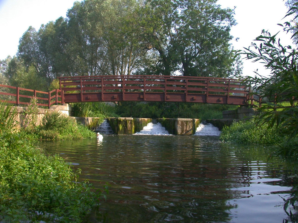
And below is how the new Stanstead New Turnpike looks today. This picture was taken while standing in the main river. The millstream is behind the weir and flows from left to right. In the top right hand corner of the picture, behind the bridge, there is a small sluice gate that controls the amount of water that passes into the final section of the millstream downstream towards the village of Stanstead Abbotts and the corn mill.
The Millstream
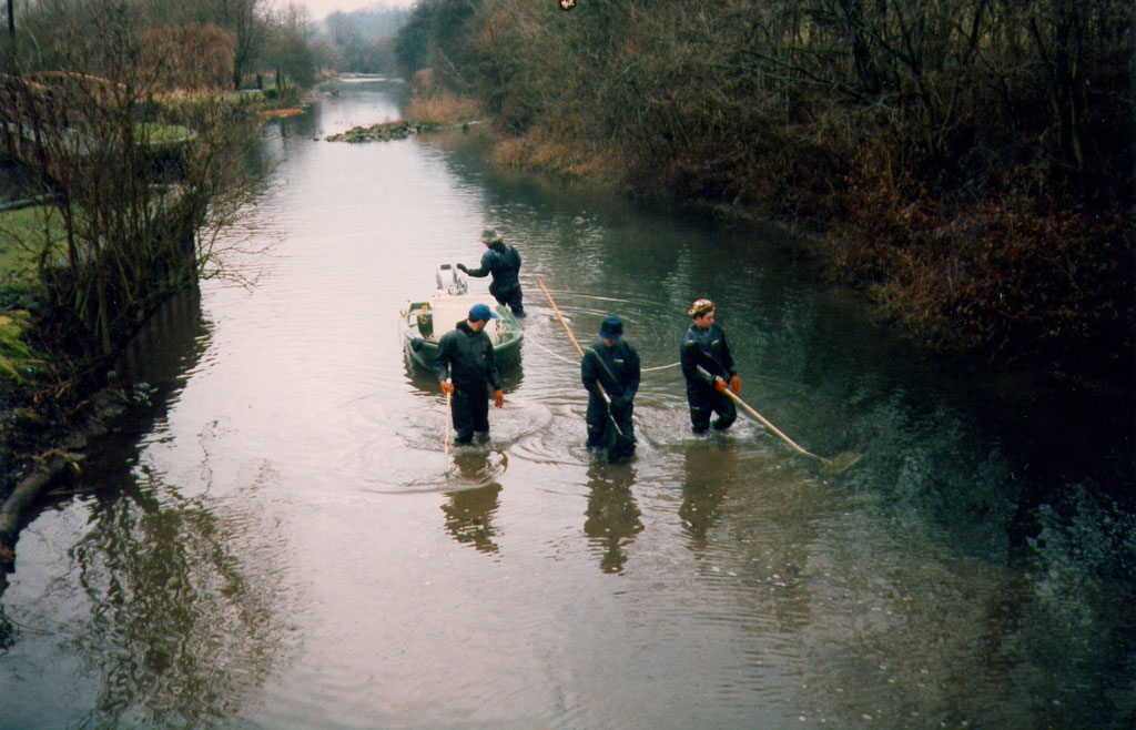
As can be seen from the picture below, which was taken during an electro-fish in the 1990s, the mouth of the millstream is very wide; indeed the entire length of the millstream between Stanstead Old Turnpike and Stanstead New Turnpike is probably between 20 to 30 feet wide. After the millstream passes behind Stanstead New Turnpike it abruptly narrows to a more appropriate width, approximately 6 to 10 feet wide. It continues at this width all the way along its journey through the village and into the mill.
The picture is taken looking upstream, the main river in the background flowing towards the viewer. The Stanstead Old Turnpike is on the left of the picture with the mouth of the millstream directly in the foreground. It should be noted that the main river is very wide, very straight, almost canalised, and not very natural for a river. And below is the millstream just after it passes the Stanstead New Turnpike, greatly reduced in width.
So What’s the Problem?
From looking through all of the information on Richard’s website and Keith’s work something just didn’t make sense, it didn’t add up.
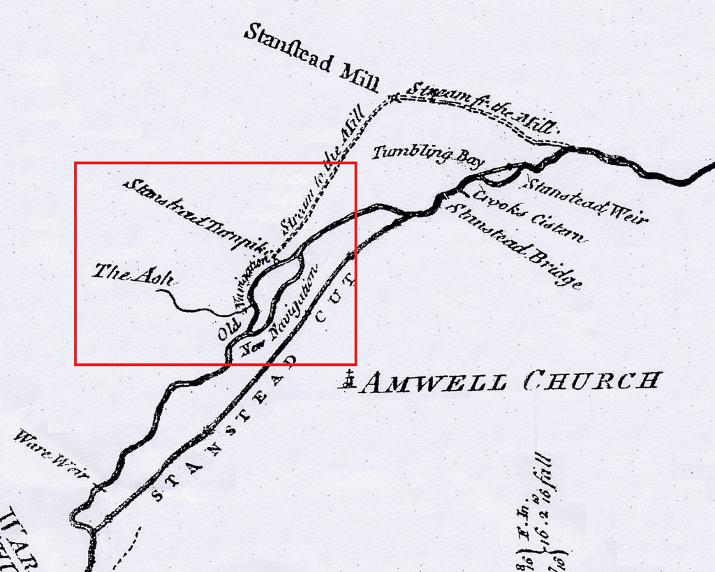
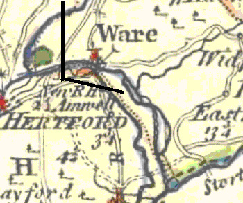
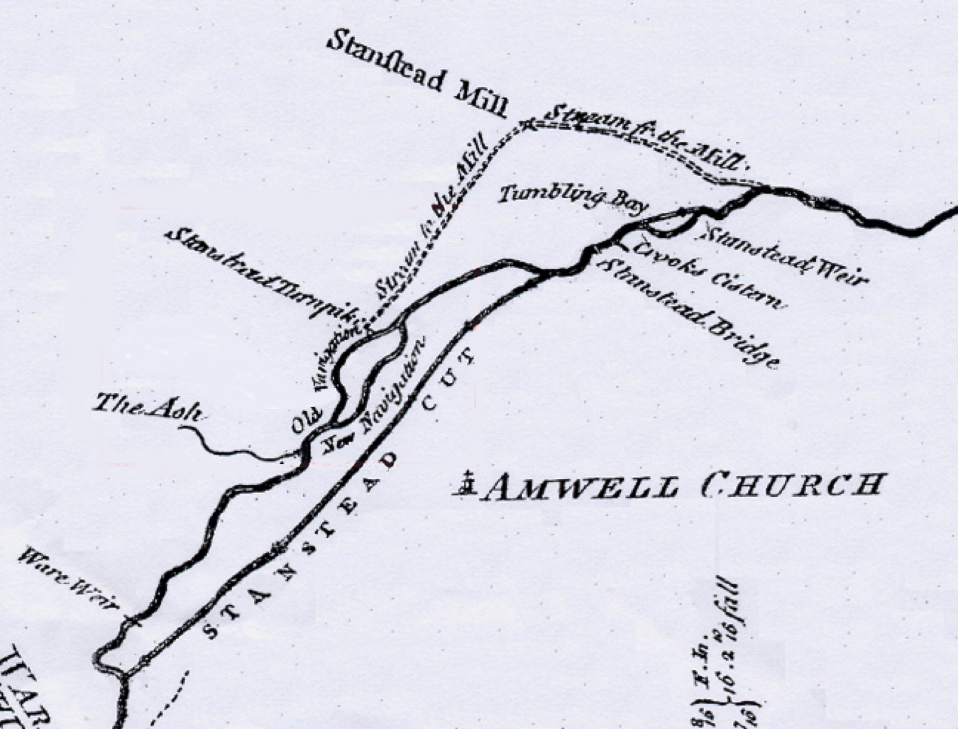
Above is one of John Smeaton’s working maps of the new Lee Navigation possibly dated about 1805. Within the red square is ‘The River Ash’, ‘Stanstead Turnpike’, (which Richard Dean refers to as ‘Stanstead Old Turnpike’), ‘Stream to the Mill’, ‘Old Navigation’ and ‘New Navigation’. The New Navigation is marked along the course of the river towards the bottom right hand corner of the red square and the Old Navigation is marked along the top branch of the river, including the Ash and Stanstead Turnpike.
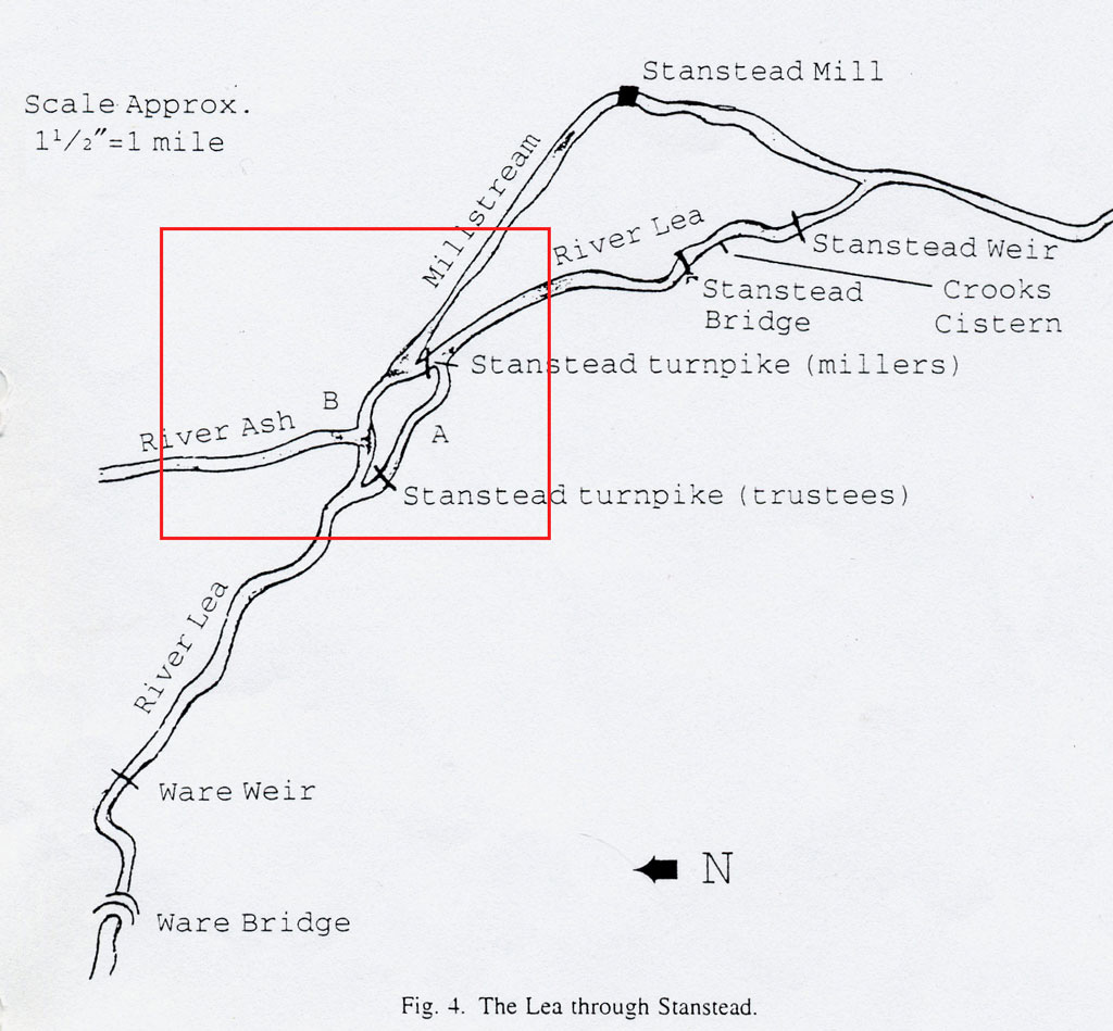
This can be compared with the map below which is taken from Dr. Keith Fairclough’s paper Navigation Devices along the River Lea, 1600-1767, read at the Science Museum in London on 11th November 1992.
Keith’s map follows the same basic pattern as Smeaton’s, travelling left to right, the River Lea, the branch in the river, bottom branch marked ‘A’ passes through ‘Stanstead Turnpike (Trustees)’, while the top branch marked ‘B,’ meets with the River Ash and then proceeds to the ‘Stanstead Turnpike (Millers)’ and the millstream. The section of Dr Fairchild’s paper describing this area follows:
The Miller’s Turnpike at Stanstead
When, after an absence of nearly 20 years, a Commission of Sewers set to work along the river in 1719 there were complaints about developments at Stanstead in the intervening period. The bargemen noted that the navigable channel had become so silted that for the previous 14 or 15 years they had been forced to use an alternative route down the head stream of Stanstead mills, through a turnpike at the head of another channel which led back to the river (see Fig. 4), paying the miller a toll of 1s for passing through his turnpike. This situation had arisen through the deliberate actions of the miller. He had thrown earth into the river, and had extended a point of land at the mouth of the head stream into the river channel so that more water was diverted to his mills. The bargemen had acquiesced in these developments but they were ‘illegal’, so the Commissioners decreed that the miller remove the encroachments so that the river channel could be used once more. The miller publicly consented, but either ignored the orders altogether or made the same encroachments soon afterwards, for by 1725 the bargemen were using his turnpike once more and did so until the early 1740s, when further attempts were made to re-open the river channel.
And when we checked the minutes of the Commissioner’s meeting at the National Archives the instructions given to William Whittenbury, the River Lea Trust surveyor on November 3rd 1742 were as follows:
IT IS FURTHER ORDERED by this Court that William Whittenbury surveyor for this said River Lee to faithfully survey that part of this said River Lee in Amwell aforesaid at or near the Mouth of the Stanstead Mill Stream River (and which is called the Old Way of Navigation) and make an estimate of the charge and expense of scouring the same in such a manner as will make the said River Lee thoro (by this help and assistance of a Turnpike to be build below the place so landed up) fit and convenient for the passage and repassage of boats and barges in through and along the same and the said surveyor is further ordered to take a survey of the said River Lee below the parts so landed up and to pick upon the most proper place for the working of the said Turnpike so far as the said River Lee which when worked shall pen the water of the said River Lee to a level with the pen of the water in the Stanstead Mill River at the Turnpike now standing on the said Mill River.
Question?
As can be seen from Dr Fairchild’s map, one turnpike was proposed to be situated upstream of the confluence of the River Ash and across the lower branch of the river; while the other was across the river at the head of the millstream. Yet the physical evidence on the ground would suggest, as Richard Dean has done in his map, that this can’t be correct, as both weirs were, and still are, situated between the millstream and the course of the main river.
The Branch in the River
To help resolve this dilemma it is first necessary to deal with the branch in the river which is shown on both Smeaton’s map and the one published by Keith Fairclough.
There was indeed originally a branch in the river, but historically it diverged from the main river someway above the confluence with the River Ash. On the right it is shown on an OS Map from the 1960s.
Following the course of the river from the top left hand corner it passes under the old Buntingford railway line and just below the bend, the river branches and a small waterway diverges and winds its way through the centre of the valley before re-joining the main river (at the spot marked as the most southerly FB on the map). This waterway was obliterated in the 1970s and 80s when gravel extraction began at Amwell Quarry, which created the large lake which exists today.
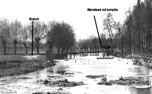
However, this waterway was never more than a small ‘diversion’ of the main river, in reality not much more than a ditch with water in it. Below is a picture taken in 1888 by Peter Emerson for the 100th edition of The Compleat Angler, published by one of the Amwell Magna Club’s members.
The view is looking upstream. The spot where the branch re-joins the main river is on the left; as you can see it is quite a small waterway in comparison to the main river in the background. At this point the main river has just fallen over the Stanstead Old Turnpike that is out of sight on the right.
From the club’s records this side stream was vitally important for the river’s trout, it was one of the places on the fishery where trout spawned during the autumn months. Spawning trout require some very simple but quite specific conditions: a plentiful supply of shallow, well oxygenated fast following water, approximately 10 to 15 cms in depth and with a clean gravel bottom.
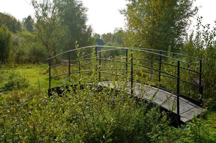
There is also an artefact from this period that has also survived, an old Victorian footbridge that once spanned this side stream just after it diverged from the main river below the railway bridge. Having been saved during the gravel excavations it now forms part of the Dragonfly Trail at the local nature reserve.
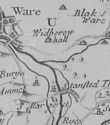
The branch also does not appear on any map prior to Braughing’s map of 1759, which is reproduced on the right. The branch is below the town of Ware and opposite the confluence of the River Ash.
Every earlier map shows the same basic features, the town of Ware, the confluence with the River Ash, the sharp, almost 90 degree bend in the river, the mouth of the millstream and then down into the village, but you will note, no branch in the river.
To the left is Morden’s map of 1695 that provides an example of the earlier maps. It is worth noting that Morden’s map includes the millstream, branching away from the main river, flowing through the eastern side of the village, where the corn mill is located, before re-joining the main river south of the village of Stanstead Abbotts.
The Birth of a Millstream
The Domesday Book records that there was a mill in Stanstead Abbotts so it can be assumed that from at least the 1080s the River Lea was used as a source of power to drive the mill since windmills did not appear in England until the 12th century.
From the depiction of the millstream in Morden’s map of 1695, the mill would clearly be, at that time, at exactly the same location as the building that still stands to this day, on the eastern side of the village of Stanstead Abbotts. It is fair therefore to assume, as Morden highlighted, that the millstream in its current form existed from at least the late 1600s.
The club’s archives contain a letter from the New River Company to Sir Francis Chantry and dated 26 Oct 1837. They were discussing Chantry’s pending lease of the fishery. It states “There is a small island on which formerly stood the ancient fishery house, which I think should be held with the fishery in case you should wish to erect a fishery house across the River.”
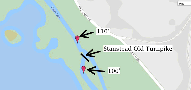
Looking at the ground elevations in the surrounding area, there is a natural drop in ground level around this section of the main river, from approximately 110’ (Above Sea Level) above the Stanstead Old Turnpike, to approximately 100’ ASL below it.
The main river continues to drop to 95’ ASL by the time it reaches the confluence with the Lea Navigation whereas the millstream drops at a much gentler rate from 110’ ASL next to Stanstead Old Turnpike to approximately 99’ ASL next to the mill in the village.
So here a number of things are coming together. The island referred to in the New River Company’s letter, where ‘formerly stood the ancient fishery house,’ is the same one where the company built keeper’s cottage in 1839, the group of buildings shown in the photographs above.
From Morden’s map the mouth of the millstream is at the same point on the river as it is today and this position probably dates back to the Normans in the eleventh century. From the geography of the surrounding land the most practical point along this stretch of river to dig a millstream would be where it currently is and where it has been for at least the last 400 years.
The first structure put across the river would have been at the location identified by Dean’s map as Stanstead Old Turnpike. If a water supply for a mill is to be created it would require a dam or some form of control across the main river to divert water into the millstream.
It is uncertain whether this dam or weir became a fishing weir as indicated by the New River Company records, when the ‘ancient fishery house’ existed? Or whether was there already a fishing weir in place indicating that this was the most appropriate location for the head of the millstream.
WHICH WATERWAY WAS THE NAVIGATION?
Dr Fairclough has charted the development and industrialisation of the river in his doctorate dissertation The River Lea 1571-1767: a River Navigation prior to Canalisation and other papers around the same subject.
Picking up on some of the points he raised we know that there was some discussion about this section of the river as far back as the Commission of Sewers in 1575, when the overall intention was to ensure that the whole of the River Lee was navigable requiring the removal of fishing weirs, gravel beds, etc and agreements with various millers and landowners restricting the amount of water taken out of the river were made. However, the new system probably only lasted until the 1590’s when the old system was reinstated.
As is mentioned above, and as you can see from the electrofishing photograph, this top section of the millstream is very wide, approximately 20’ to 30’ but suddenly narrows to 6’ to 10’ once it passes the site of the second weir, the Stanstead New Turnpike.
The change in width of the millstream is clearly visible in the OS Map above.
The barges would have been coming off the main river at Stanstead Old Turnpike into the head of the millstream (the New Navigation”) and then along to the flash lock at Stanstead New Turnpike before returning to the main river.
This, of course, would mean that the old route, pre 1500s for the barges was in fact through Stanstead Old Turnpike, following the original course of the river, and not as Smeaton suggested following the branch out through the valley floor. In fact what Smeaton’s ‘Old Navigation,’ should have showed was the original route through Stanstead Old Turnpike along the course of the river and his ‘New Navigation,’ was to continue along the head of the millstream and through Stanstead (new) Turnpike back into the river.
And, as Dr Fairclough suggests, this “new Navigation” was the basis of the bargemen’s protests in the early 1700s, when the miller apparently was forcing the barges to use the route through the head of a (new navigation) millstream and then back onto the main river through the Stanstead New Turnpike, charging a suitable toll of 1/-in the process. The miller would have had to widen and deepen (canalise) the short section between the two turnpikes to make it suitable as a navigation. This came about possibly following the much longer canalisation of the Ware Mill headstream some years before in 1658. When this was proved successful, the miller at Stanstead was probably not one to turn away a moneymaking scheme and he followed suit by carrying out a similar operation at the head of his millstream.
It seems that he possibly did this without obtaining the Commissioner’s approval because they ordered, (albeit with the miller’s consent, which he couldn’t really withhold) that the traditional channel be used once more. Yet by 1725 the miller was still collecting 1/-toll, the Commissioner’s orders having been ignored.
This disagreement seems to have gone back and forth for a number of years until 1742 when the Commission of Sewers recommended that the traditional river route be re-opened as soon as possible. (See the extract from the minutes below).
“IT IS FURTHER ORDERED by this Court that William Whittenbury surveyor for this said River Lee to faithfully survey that part of this said River Lee in Amwell aforesaid at or near the Mouth of the Stanstead Mill Stream River (and which is called the Old Way of Navigation) and make an estimate of the charge and expense of scouring the same in such a manner as will make the said River Lee thoro (by this help and assistance of a Turnpike to be build below the place so landed up) fit and convenient for the passage and repassage of boats and barges in through and along the same and the said surveyor is further ordered to take a survey of the said River Lee below the parts so landed up and to pick upon the most proper place for the working of the said Turnpike so far as the said River Lee which when worked shall pen the water of the said River Lee to a level with the pen of the water in the Stanstead Mill River at the Turnpike now standing on the said Mill River.”
From the description given, there could be only one possible location for this construction: the site of the Stanstead Old Turnpike, and not across the mouth of the branch below the railway line. The Commissioner’s turnpike was completed in 1743 and the river below it scoured and traffic returned to the original route. In other words Smeaton’s map of 1805 should have looked as shown below: (Note the repositioning of the River Ash).
Debate about this newly built turnpike was to continue for some time, the miller feeling that there was now too little water in the millstream and that his land had been damaged during the building of the turnpike and that the operation of the turnpike harmed his mill and two fishing weirs. The fishermen who leased Feilde’s weirs also complained that their livelihood had suffered. This continued until 1748 when the Commissioners possibly felt that a permanent presence or guard against misuse should be provided and ordered William Whittenbury to build “a lodging room over the turnpike machinery at a cost of £12.” It is possible that this lodging room was the origin of the New River Company’s idea of the ‘ancient fishery house’ and eventually, led to the building of the keeper’s house illustrated above.
Conclusion
Based on the above it would seem that there have only ever been two weirs on the river and that their development was as follows:
There was some kind of possibly navigable structure in or across the main river at the location marked by Richard Dean as the Stanstead Old Turnpike, perhaps as far back as the Domesday Book, used to divert water into the mouth of the millstream. At some point this developed into a weir, flash lock or turnpike of some description.
By the early 1700s, the miller at Stanstead Corn Mill had blocked the old turnpike and was diverting barges along the head of the mill stream to pass through a new turnpike, the Stanstead New Turnpike, charging a 1/-toll each time a barge wanted to pass through.
In 1743 the Commissioners and Trustees rebuilt the original turnpike, back at the site of the Stanstead Old Turnpike, and reopened the original course of the river to traffic thereby shutting down the route along the millstream
This shows that Smeaton was mistaken as to the position of the ‘old’ and ‘new’ navigations on his map. Indeed, in earlier versions of the River Lea map, the two waterways were labelled incorrectly, their descriptions being reversed. This error led Keith Fairclough to position the Stanstead Turnpike (Trustees) and the Stanstead Turnpike (Millers) in the wrong places (see map). The former structure is the ‘Old’ Turnpike and the latter, the ‘New’, shown on the map immediately above.
At their meeting of April 30th 1746 the Trustees of the River Lea ordered that the turnpike keeper should live onsite and that a lodging room be built over the Stanstead Old Turnpike at a cost of £12. Was this the ‘ancient fishery house’?
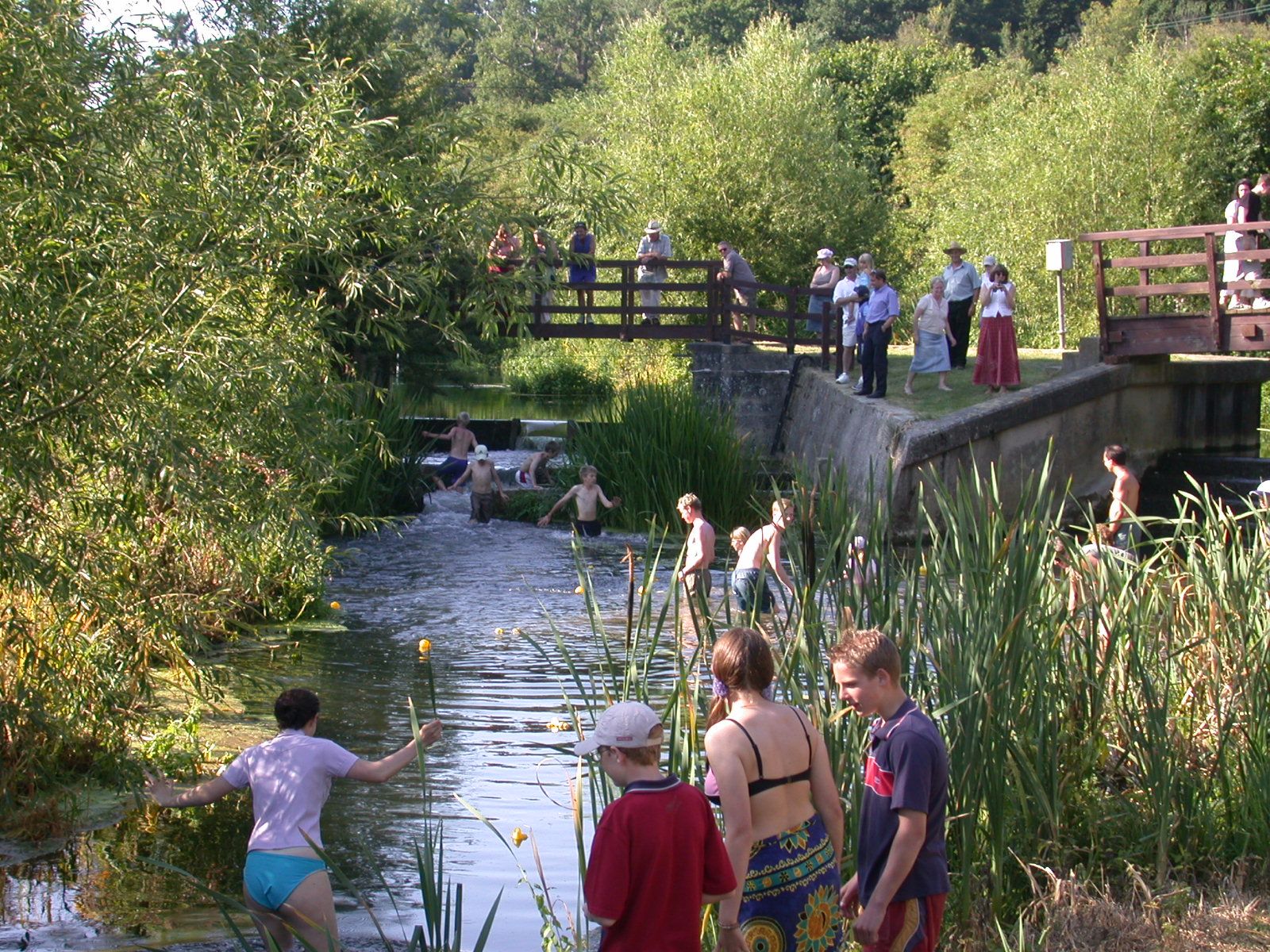
Here is how the site of the Stanstead Old Turnpike looks today, taken during the Duck Race, for many years a feature of Amwell Magna Fishery’s annual picnic.
1 William Shackell Established the John Bull newspaper with Theodore Hook in 1820, imprisoned for libel, in 1821, 1822 and 1827. He was bankrupted in 1848. 2 Placita de Quo Warranto, Temporibus Edw. I. II. & III page 283.
2 Placita de Quo Warranto, Temporibus Edw. I. II. & III page 283.
3 Advert Herts Reformer, February 16th 1836 and minutes of the New River Company board 24th March 1836.
4 The Ware fishery ran from the Manifold Ditch, just north of the town of Ware, down stream to the Tumbling Bay weir, on the southern edge of town. Historically the fishing rights in this section of the River Lee had belonged to the Byde family as part of the Ware Park estate but was acquired by the New River Company under an Act of Parliament when they purchased Ware Mills, House of Lords Record Office 11 Geo II, c.14PR, 1738
5 http://www.leeandstort.co.uk/Lee History/18.19 Victoria c196 1855.pdf
